
Page 16 - Curriculum Visions Dynamic Book. To close the book, close the tab.
P. 16
Depression
D
Depression
A mid-latitude cyclone or ‘low’ carried by the westerly winds. Warm tropical air and cool polar air are drawn together. Where the cold and warm air meet, zones of activity, called fronts, occur. The leading front is called a warm
front, and the trailing zone of activity is called a cold front.
The cold, denser air cuts under the warm, less dense air. As the warm air rises, it cools, producing broad bands of cloud and rain
(or snow) along the frontal zones. Within a depression air spirals counter-clockwise in the Northern Hemisphere and clockwise in the Southern Hemisphere.
Depressions are constantly forming, maturing and decaying as they travel westwards around the world. Each depression is steered by a fast-flowing region of air called the jet stream, which is located high in the atmosphere.
By tracking the jet stream, weather forecasters are able to predict the movement of the depressions and their accompanying clouds and rain.
X
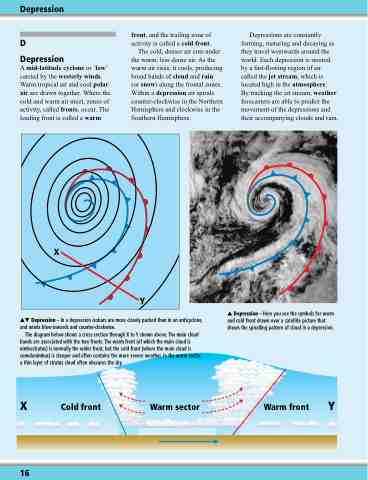
Depression – In a depression isobars are more closely packed than in an anticyclone, and winds blow inwards and counter-clockwise.
The diagram below shows a cross-section through X to Y shown above. The main cloud bands are associated with the two fronts. The warm front (of which the main cloud is nimbostratus) is normally the wider front, but the cold front (where the main cloud is
Depression – Here you see the symbols for warm and cold front drawn over a satellite picture that shows the spiralling pattern of cloud in a depression.
Y
cumulonimbus) is steeper and often contains the more severe weather. In the warm sector a thin layer of stratus cloud often obscures the sky.
X Cold front Warm sector Warm front Y
16
