
Page 15 - Curriculum Visions Dynamic Book. To close the book, close the tab.
P. 15
Cumulonimbus cloud
A very deep form of cumulus cloud, mainly linked to thunderstorms. Nimbus means rain-bearing (see: Virga). The biggest cumulonimbus clouds form over very hot continents, where there is a flow of moist air. The Great Plains region of the United States has many cumulonimbus clouds in summer, when warm, moist air is sucked from the
Gulf of Mexico and heated daily by the strong summer sunshine. Cumulonimbus clouds often signal tropical cyclones and the cold front of a depression. All tropical rainclouds are of the cumulonimbus kind.
Current
A concentrated flow of air, such as a jet stream, or a concentrated flow of water, such as the Gulf Stream.
Cyclone
A large area of the atmosphere where the air is swirling inwards and upwards in a corkscrew-like manner. Air spirals counter- clockwise in the Northern Hemisphere and clockwise in the Southern Hemisphere. Depressions are actually weak cyclones, but
that term is usually used only for tropical cyclones (called hurricanes in the Americas and typhoons in the West Pacific).
The causes of depressions and tropical cyclones are completely different, however.
Cyclone
Cumulus cloud
Individual clouds that form in a sky when warmed air is rising.
They are especially dramatic in the tropics and in the centres of mid-latitude continents during the hot summer season, when they can bring downpours and spawn tornadoes. Cumulus clouds are formed by convection currents and tend to form on a daily basis when there is strong sunshine and moist air. The day may start fine and clear, but ground heating soon occurs, and this heat is transferred by conduction to the lower layers of air. This warmed air then begins to rise, so that cumulus clouds are bubbling up by mid-morning. By
midday the clouds may cover the sky. Cumulus clouds fade away
in the late afternoon because the Sun is lower in the sky and can no longer heat the ground strongly.
The level at which the moisture in the parcel of rising air condenses to form the cloud.
Cumulus cloud – The diagram shows how air rises to form cumulus clouds.
Warm bubbles of air rising from the warm ground gradually get colder. Although they are still warmer than the surrounding atmosphere, the cooling bubbles cannot hold all of the moisture they had when nearer the ground, and at a certain height some of it condenses onto tiny particles of dust floating in the air.
Air bubbles remain invisible until the critical height is reached, and then condensation occurs. This height is the bottom of the cloud.
If the cloud becomes thick, the water droplets and ice crystals will grow big enough to fall from the air as rain or snow.
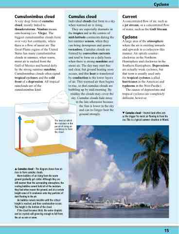
Cumulus cloud – Heated land often acts
as the trigger for moist air flowing in from the sea. This is a typical summer situation in Miami.
15
