When the United States of America was formed, after the end of the Revolutionary War, the country was much smaller than it is today. In 1783, America signed a treaty with Britain that gave the new country all the land east of the Mississippi River that was owned by Britain, except Florida and the Port of New Orleans, which were owned by the French and Spanish. There were around 3 million people living in America at that time, but two-thirds of them lived within 50 miles of the Atlantic coast. At that time, there were no railroads, and very few roads outside the cities. People and goods usually traveled from state to state by river, or by sea. These journeys could be long, dangerous, and expensive, so people only traveled away from the well-populated areas if they had to.
When America became a nation, some people living along the east coast began to look to the west. There was a lot of land in places like Kentucky and Tennessee that was not yet settled. To encourage settlement, the government offered land for free or very low prices. Some people began to think it made sense to take the chance, move west and start a farm or a cattle ranch.
In 1803, the U.S. government bought most of the land between the Mississippi River and the Rocky Mountains, called the Louisiana Territory, from the French. This was the Louisiana Purchase. The land cost the U.S. government $15 million – about 3 cents an acre. This purchase doubled the size of the young country and opened up a huge amount of land to settlement. Of course, almost all of this land was empty – there were no stores, no roads, and no cities. Parts of the land in the Louisiana territory were also already occupied by Native American Indians. Some Indians were willing to share the land, but many of the Indian tribes were prepared to fight to keep their land and their way of life.
Gradually, people began moving out to the new territory. Some of them were trappers and hunters, and some were farmers looking for new land. As more and more people moved west, they pushed the boundaries of settlement farther and farther west.
In 1845 and 1846, the U.S. grew again. Most of the land west of the Rocky Mountains in the north, had belonged to Spain. In 1836, the American colonists in Texas went to war with Mexico over control of what is now Texas. The U.S. defeated the Mexican army and the end treaty gave the U.S. all the land that is now Texas, California, Nevada, Utah, Arizona and New Mexico.
That same year, the U.S. signed a treaty with Great Britain. Britain still controlled the area that is now Canada, as well as parts of Oregon, Washington, Idaho, Montana and Wyoming. In 1846 Britain agreed to draw the border between the U.S. and what would become Canada at the 49th parallel.
Thus, by the end of 1846, the United States had reached most of its present shape – it stretched from Atlantic Ocean to Pacific Ocean (from ‘sea to shining sea’). But most of the land was still sparsely populated. Although there were many tribes of native American Indians living on the land, they were spread out and lived in small communities. Yet all over this sparsely populated land, people had begun to move west, always in search of new land and new opportunity. This trickle of settlers would soon grow to a flood, and come into conflict with the native Americans.
The new U.S. government wanted to know what kind of land the North American continent was, and so, in 1803, President Thomas Jefferson organized a secret mission to send a small party (called the Corps of Discovery) led by Meriwether Lewis and William Clark overland to the Pacific, something no one before had tried. It was secret because Lewis and Clark would be going outside what was at that time the United States and onto British and Mexican lands.
Although Lewis and Clark did reach the Pacific, their route was far too difficult for wagon traffic. So, for the time being, westward expansion as far as the Pacific, had to wait. In the meantime, pioneers poured into the Ohio Valley and began to colonize the eastern prairies. So there was an enormous pent-up pressure to move west if they could.
In 1825, frontiersman Jedediah Smith re-discovered South Pass. Smith made sure everyone knew about this important route. Between 1826 and 1830 he made one of the first accurate maps of the area. It is now known as the “Fremont-Gibbs-Smith map.” It covered not just Oregon, but all the way into what was then Mexico. Frontiersman Joe Walker and U.S. army captain Benjamin Bonneville found another pass, this time to California. Later it was used by the transcontinental railroad and can still be followed today.
What happened next was due to a change of fashion in the east. The mountainmen had made money by selling furs. Then, in the 1830s, the furs went out of fashion, so they had to look for a new source of income. This was when they Used their skills in crossing the mountains to advertise and lead wagon trains. The pioneer age was beginning.
Explorer John Fremont journeyed west along the Oregon Trail in 1842 and 1843. His wife’s father was the powerful Missouri senator Thomas Hart Benton. Benton believed America had a right to all the lands of the west, and that the country had a destiny to stretch from Atlantic to Pacific. This idea was called “Manifest Destiny.” Fremont was sent west with instructions to make the west seem attractive, and thus increase the number of pioneers. His wife wrote, then sent back east, the reports that fueled the great migration west.
We tend to think of the pioneers on the Oregon Trail as farmers, but the first were actually Christian missionaries intent on converting the Native Americans.
Life on the frontier was very hard and lonely, and the native Americans were not interested in converting to a new religion. Marcus Whitman then acted as a guide to more than 1,000 people who wanted to move west. Their Whitman mission became an important stopping point for new settlers. So it was the Whitmans who founded the Oregon Trail and begun the Great Migration west, but in doing so they caused the destruction of the Native American peoples on the way.
The Oregon Trail was not the only way to get to Oregon of course. People had been going by ship around the tip of South America for a long time. But that was simply too expensive for most people. The cheapness was what made the Oregon Trail so attractive.
Although it was practicable, it was not for the ill-prepared or weak. Around one in 10 people died along the way.
Despite what is shown in movies, most native American tribes were actually helpful to the emigrants, and traded with them. The real enemies of the pioneers were cholera, poor sanitation and accidents.
The 1843 wagon train led by Marcus Whitman started off a massive move west along the Oregon Trail. Over the next 25 years more than a half million people went west on the Trail. Some went all the way to Oregon’s Willamette Valley in search of farmland, while many more split off for California. The years of the wagon trains along the Oregon Trail finally ended in 1869, when the transcontinental railroad was completed – providing a faster and much safer route west.
Not everyone who went west was driven by hopes of a better life, some were driven by a desire for religious freedom. Among these were the followers of Joseph Smith – known as the Church of Jesus. Christ of Latter-day Saints, or Mormons.
Brigham Young, the new leader of the group, decided they needed to migrate west. Young had never been west of the Mississippi, but he had read the writings of explorer John C. Fremont, and decided the Great Salt Lake River valley, in the Utah Territory (then a part of Mexico – but it would become part of the U.S. after the Treaty of Guadalupe Hidalgo in 1850) might be the perfect place to settle.
Over the next two decades more than 60,000 Mormons would journey to the Utah Territory; thousands came by wagon, and thousands more pulled handcarts.
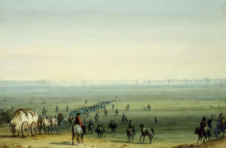
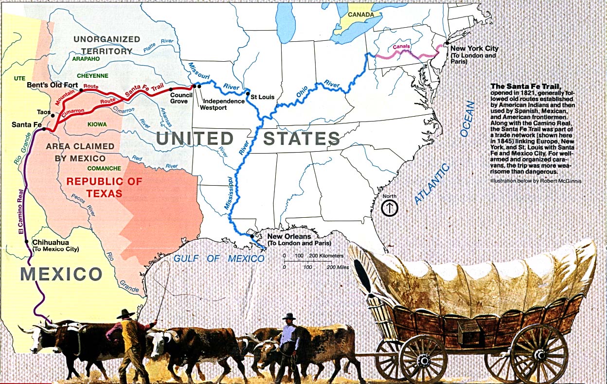
The Santa Fe Trail was the other route, in this case to the southwest. It was opened by the Spaniards at the end of the 18th century, connecting Independence, Missouri with Santa Fe, New Mexico.
The Santa Fe Trail developed in 1828 to take advantage of new trade opportunities with Mexico which had just won independence from Spain. The trail was used to take manufactured goods from the state of Missouri in the United States to Santa Fe, which was in the northern Mexican state of Nuevo Mexico.
Because it was in what was still Mexico, until after the US-Mexican war, there was little appetite for migration. After this, people did begin to go this way, although, as the land was quite arid, many few people traveled this way than on the more northern routes. The trail was 900 miles (1,400 km) of dry plains, desert, and mountains. Also, on this trail unlike the Oregon trail, there was a serious danger of Native American attacks, for neither the Comanche nor the Apache of the southern high plains tolerated trespassers.