
Page 25 - Curriculum Visions Dynamic Book. To close the book, close the window or tab.
P. 25
(Left) Rifting occurred at the head of L Street in Anchorage during the earthquake. Land sank about three metres as a result of the area to the left moving nearly four metres sideways.
A number of houses seen in this photograph were undercut or tilted by subsidence of the rift.
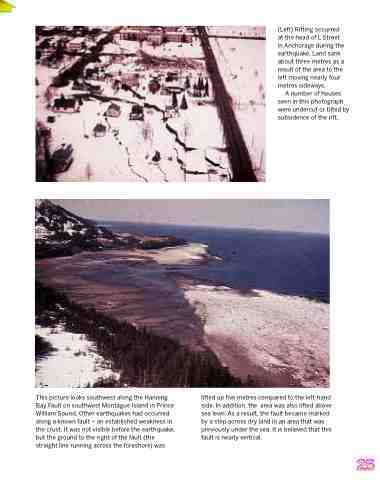
This picture looks southwest along the Hanning Bay Fault on southwest Montague Island in Prince William Sound. Other earthquakes had occurred along a known fault – an established weakness in the crust. It was not visible before the earthquake, but the ground to the right of the fault (the straight line running across the foreshore) was
lifted up five metres compared to the left-hand side. In addition, the area was also lifted above sea level. As a result, the fault became marked by a step across dry land in an area that was previously under the sea. It is believed that this fault is nearly vertical.
25
