
Page 4 - Curriculum Visions Dynamic Book. To close the book, close the tab.
P. 4
Air pressure
Air pressure
The force per square metre exerted by the air on the ground. An area of high pressure is formed where air currents make air sink over a region of the Earth; an area of low pressure is a region where air is rising and so reducing the typical weight of air at that place. A high pressure region can also be caused by air flowing into a place faster than it flows out. A low pressure area can be formed if air flows
out faster than it flows in. These effects are commonly a cause of depressions in the mid-latitudes.
Airstream
A flow of similar air, for example, a flow of westerly winds across the Atlantic or Pacific.
Albedo
Used in meteorology to describe the reflectivity of natural surfaces.
A surface, such as bare rock, has an albedo, or reflectivity, of about 30%, meaning that 70% of the light is absorbed. Oceans can have albedos as high as 90% if
the Sun is overhead at the tropics, but as little as 10% at sunrise or sunset or in polar latitudes. These differences affect the amount of heat the Earth is able to absorb from the Sun.
However, the greatest albedo of all is from the top of clouds
and from snowfields, which often register over 95% albedo.
Aleutian low
A part of the atmosphere above the northeast Pacific Ocean that commonly has low pressure air. It is a place where low pressure systems, or depressions, are formed, or where they grow (deepen). It is strongest in winter.
Altitude
The height above sea level. It is measured in metres.
Alto-
Used when describing clouds, meaning medium height.
4
Altocumulus
A word used for cumulus clouds of medium height. They are thin clouds and normally look white. They form as a result of upwards movement of the air. Sometimes this is a result of convection,
in which case the clouds make patterns of flat cumulus clouds that look like fish scales. This pattern is sometimes described as mackerel sky.
At other times the clouds are
the result of bands of air moving upwards. When this happens, cumulus clouds form in bands, with clear sky in-between. The bands of clear sky distinguish cumulus from stratus cloud. Altocumulus clouds are often a sign of fair weather.
Altocumulus – Compare the altocumulus in the foreground with the cumulonimbus cloud in the distance.
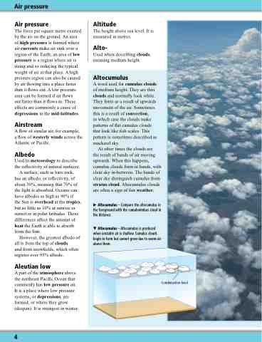
Altocumulus – Altocumulus is produced when unstable air is shallow. Cumulus clouds begin to form but cannot grow due to warm air above them.
Condensation level
