
Page 16 - Curriculum Visions Dynamic Book. To close the book, close the window or tab.
P. 16
depths from the surface down to about 70 kilometres
are classified as shallow. Earthquakes with focal
depths from 70 to 300 kilometres are classified as intermediate. Earthquakes whose focal depth is greater than this are deep; those below 400 kilometres (the depth of the thickest crust) must occur in the upper mantle. Earthquakes that occur as a result of plates colliding (as shown in the diagram above) can be shallow,
ChinA
TAiwAn
TAipei
16
BuChAresT
AThens
AnkArA Turkey
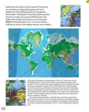
(This page) Earthquakes are happening all of the time. You can now see the earthquakes that are occurring around the world in almost real time on the Internet. This, for example, is an image downloaded from IRIS/USGS soon after the Taiwan earthquake (magnitude 7.6) of 20th September 1999; the largest circle on the map shows the Taiwan earthquake. It also shows the earthquakes that occurred during the previous five years. The circle sizes and colours show the magnitude and the age of the earthquake. This image is re-created every 30 minutes. The dark shadow shows the region of darkness over the earth at the time the image was compiled.
The top map shows the pattern of earthquakes in the Taiwan area. Notice that it follows a curved line. This is an ocean-continent tectonic plate boundary. By contrast, the bottom map shows the pattern of earthquakes around Turkey,
niCosiA a continent-continent plate boundary. There is a more widely scattered pattern here.
